

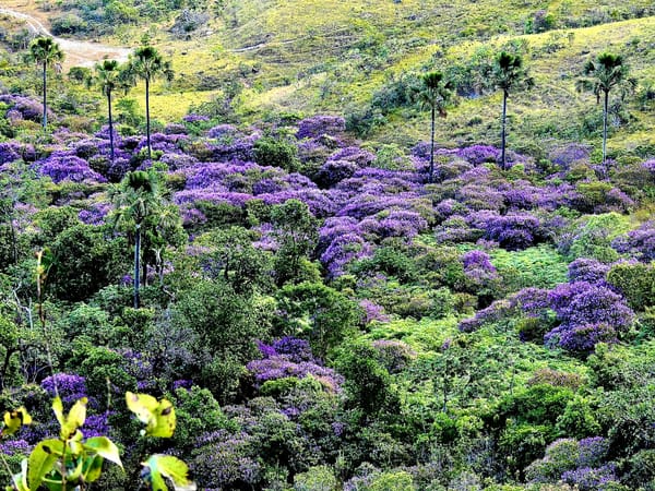
Chapada dos Veadeiros
The cradle of the crystal-clear waters of the Brazilian Cerrado
The most preserved area of the Cerrado in Goiás is in Chapada dos Veadeiros. Mountain ranges that shelter important springs and an incredible biodiversity of native fauna and flora.
History
The first records of human presence in the region are of Indigenous peoples such as the Cayapós, the Xavantes and the Guayazes. Then came the bandeirantes in search of gold mines, and Africans fleeing slavery, starting the gold-mining cycle,
From then on, the region drew many prospectors who came to exploit the precious metal and help the Portuguese Crown push the beloved homeland of Brazil “inland”. The first incursion into the territory of Cavalcante took place in 1736, by the prospector Julião Cavalcante and his companions, who came looking for new gold mines.
News of the discovery of a huge, very deep gold mine on the banks of the Lava Pés stream, in the Serra da Cavalhada, drew many adventurers from the most distant corners, and the settlement began under the name CAVALCANTE, in honor of its founder and colonizer.
Read the full history
In 1794, as the precious metal declined in the settlement of São Félix, the gold smelting house was moved to Cavalcante; it closed in 1806 after it began running at a loss. It is estimated that during the heyday of the gold mines there were about 20.000 enslaved people in the Cavalcante region, a population of enslaved people alone twice the size of today's population.
With the decline of gold, the municipality turned to other economic activities, mainly farming and cattle raising, producing sugar, meat, cassava flour and later wheat flour. For some time the municipality was the largest exporter of wheat flour to the USA, thanks to wheat of the best quality, owed to the climate, altitude and soil.
At that time the territory of Cavalcante covered almost all of northeastern Goiás, from the municipality of Formosa (the former Arraial dos Couros) to the municipality of Arraias, in the state of Tocantins.
In 1740, the settlement of Cavalcante was officially founded by the bandeirante Diogo Teles Cavalcante and Domingos Pires do Prado, in the presence of the Governor of the Captaincy of São Paulo, D. Luiz de Mascarenhas. In 1759, the settlement became a parish, by order of the Governor of the Captaincy of Goyaz, D. João Manoel de Melo.
in the surroundings of the region, which led to the rise of Cavalcante in 1740. The development of the region began around 1750, with the establishment of Mr. Francisco de Almeida's property, called Fazenda Veadeiros, where cattle raising and the small-scale growing of wheat and coffee came together. Many travelers passed through the place over the course of history:
In 1946, the new constitution provided for moving the capital inland. To that end, the Poli Coelho Commission was formed to determine the area of the new capital. The Poli Coelho Commission extended the area of the Federal District to Veadeiros (Alto Paraíso), but this area was later reduced, leaving Veadeiros outside the Federal District. One of the members of this commission was Jerônimo Coimbra Bueno, who in 1960 wrote a letter to then-President Juscelino Kubitschek asking for the creation of the Tocantins National Park, a request granted a year later with a park of 625 thousand hectares covering the whole Chapada.
In 1892, an event heralded radical transformations in the geography, politics and society of the whole region of Central Brazil: the arrival of the Exploring Commission of the Central Plateau, led by Luiz Cruls and made up of several researchers whose purpose was to mark out the area of the future capital of Brazil.
In September 1926, the famous Prestes Column crossed the Chapada. In 1931, serving the national air mail, Brigadier Lisias Rodrigues passed through Veadeiros on his way from São Paulo to Belém. This visit resulted in the magnificent literary work “O roteiro do Tocantins”.
With the inauguration of Brasília (1960), the whole surrounding region began to reflect the profound transformations set off by this event.
In 1980, two specific events, of different origins but complementary, became a decisive milestone for today's reality: the Alto Paraíso and Rumo ao Sol projects. The first, a government project, sought to install urban facilities such as a hotel, an airport and paved roads, aiming to create, through tourism and the production of high-value fruit, a regional development hub for northeastern Goiás. “Rumo ao Sol”, on the other hand, aimed to set up and develop alternative communities in the area, based on ideas from naturalism and mysticism. The project, which was like a hippie movement, attracted the first large wave of migrants to the region. From then on, and with the rise of ecotourism, Chapada dos Veadeiros and its communities have gone through many political, social and economic transformations.


Geology
The Chapada dos Veadeiros region, including Chapada dos Veadeiros National Park, is one of the oldest landforms of the Central Plateau and an important meeting point of large groups of geological formations called the Veadeiros Supergroup, which includes the Araí Group at 2,1 billion years, Traíras at 1,8 b.y. and Paranoá at 1,0 b.y.; and the Bambuí Group at 650 million years, all formed when there was still no life on Earth, which is why no fossils are found in the Chapada. This period before the explosion of life is called the Precambrian.
The tectonic meeting of these groups is what makes the region's landforms exceptional. Over time, the landscapes were shaped and changed by rain, wind, heat and the breaking down of rocks by water and plant roots, causing weathering and helping to form the valleys, canyons and waterfalls.
All this geological movement results in a remarkable diversity of landscapes, which is the basis for the unique biodiversity of the region. Geological processes combined with ecological ones and the wide range of altitudes also give rise to countless attractions and opportunities for recreation and experiences in contact with nature.
Text: Joana Sanches – UFG
Flora
The poet and environmentalist Nicholas Behr put it well: “Not everything crooked is wrong. Look at Garrincha's legs and the trees of the Cerrado.” Indeed, many who look at Brazil from the perspective of the Amazon Rainforest or even the Atlantic Forest, with leafy trees, large leaves and lots of green, may miss the beauty in the details of the Cerrado, which calls for a closer look.
Keep reading
The grandeur of the Cerrado lies in its biodiversity: it is the most biodiverse savanna in the world, with about 12 thousand catalogued plants, more than 4 thousand of which are endemic, a very significant share. For this reason, the biome is considered a global biodiversity 'hotspot', meaning it has a high number of endemic species while being seriously threatened, which makes it in a way “irreplaceable” and a priority for conservation. The Cerrado has a seasonal climate, with two well-defined seasons over the year, a rainy summer and a very dry winter. Plants have had to adapt to these conditions with their survival strategies, and perhaps for this reason the biome has a high rate of endemism.
Species have had to cope with the droughts they face every year and the occasional fires that reach them in that period. So one can see plants with many adaptations aimed at storing water, avoiding water loss and protecting themselves from fire. Among these adaptations: deep roots able to reach parts of the soil where there is water, especially in the dry season; some plants go dormant during this period, needing less water for their metabolism; a high capacity to store water and nutrients, in the roots or trunks; leaf features that prevent excessive water loss; among others. As for fire, many species recover quickly after burning, some have trunks with thick bark or even underground trunks that protect them, and some have their flowering triggered by fire. These features make it possible for green to take over the biome shortly after the first rains, following a long period of drought and fire.


Fauna
The Cerrado biome has a great diversity of landscapes made up of different types of vegetation, which place it among the savannas with the richest flora in the world (MENDONÇA et al., 1998). This variety of habitats favors the diversity of the fauna. For these and other reasons the Cerrado is considered one of the most important biomes in the world, holding 5% of the planet's biodiversity: about 7.000 species of plants, 1.200 of fish, 150 of amphibians, 180 of reptiles, 837 of birds and 199 of mammals, of which 44% of the vascular plants, 28% of the amphibians, 17% of the reptiles, 3,4% of the birds and 9,5% of the mammals are endemic to the biome.
Keep reading
It is not very common to walk into an area of Cerrado and come across mammals, since most of them shelter (or take refuge) in well-preserved areas where they can find food. A few can be seen more often, such as the opossum, the capybara and the black-tufted marmoset. Among the best-known mammals, besides the maned wolf, there are the jaguar, the giant armadillo, the red brocket deer, the hoary fox, the little spotted cat, the capuchin monkey, the giant anteater, the otter, the collared peccary, the white-lipped peccary, the paca and many others.
Unfortunately, with the advance of agribusiness, wild animals are having their homes invaded. To keep their generations alive, they must migrate to the islands of cerrado left among the large plantations.


Communities
Support community-based tourism in the Chapada
Northeastern Goiás has incredible tourism potential, a land of beautiful waterfalls and stunning horizons. Places inhabited for many years by people who built a resilient bond with the cerrado, keeping a traditional way of life that protects the springs, the fauna and flora of the Cerrado and its rich cultural heritage. Today, local families host visitors and serve meals close to the attractions, which makes the logistics of the tours easier and strengthens a network of mutual cooperation, prosperity and friendship.
At its core, community-based tourism aims to preserve the culture of the communities, offering dignity to the most isolated families. It seeks sustainable development and a kind of tourism that is more respectful of local memory and the environment. Come and be part of this movement with a strong social impact. See below the attractions that are part of our expeditions.
See our tours